If you can see Mt. Baker, you are part of The Experience
 |
Divine DivergenceHiking the Nooksack Cirque and Yellow Aster Butte trailsBy Ryan HasertThe book drops with a familiar thud and joins the many other hiking books scattered across my kitchen table. With summer underway and fall looming around the corner, my hiking companions and I are all too aware of the small window of opportunity to hike some trails within the North Cascades mountain range. We’re anxious to seize it and, after pouring through the guidebooks, we know just where we want to go.
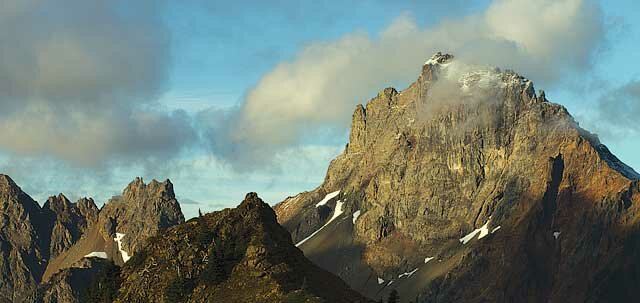
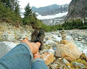
Nooksack Cirque Trail #750 We chose the Nooksack Cirque hike to start and, after the familiar eastbound drive out the Mt. Baker Highway, we take a quick left hand turn before it begins to climb up to the resort. The car follows a forest service road to the trailhead. With not much elevation threatening us, and relatively low mileage, we are traveling light. No one ever complains with a daypack. The hike begins and our spirits are high. Just a few paces in, however, and the trail forces us to ford a creek. Luckily, a well-placed log jam allows for a quick crossing and we continue onward. We are led to an old logging road with only a slight grade. It’s a welcome aspect to the hike and allows us to move that much faster. After what feels like a few gradual miles, we transition to old growth forests. My mind always wanders in these forests. I feel as though I am walking through an old photograph; the landscape around me is frozen in time. It reminds me why I enjoy hiking this area so much. The sensation makes this section of the hike a seemingly fleeting moment. Before I know it we’ve reached the end of the trail, and we stare out at the North Fork of the Nooksack River. We transition again; this time from loamy dirt to scattered river rocks and boulders. We enter the river basin and the trail ends. Surrounded by the glacial-carved walls, the cirque in the distance reveals our destination. We begin to scramble our way toward it. More focus goes into each step as I realize how hard it is to walk on river rocks, yet it becomes increasingly difficult to concentrate on my steps as the beauty of the valley begins to engulf me.
Nooksack Cirque Trail #750 is best hiked in late summer or early fall. To get there, travel east on SR 542 for 12.5 miles from the Glacier Public Service Center. Turn left on Hannegan Pass Road #32, follow #32 for just over one mile to the junction with Nooksack Cirque Road #34. Follow #34 for one mile to the parking area at the end of the road. Yellow Aster Butte Trail #699 The next morning, we packed for an overnight trip and at the trailhead in cool morning air and fog. This hardly dampens our spirits, as we are all aware of the 2,500-foot climb ahead of us, knowing sunshine may lie just above the layer of fog. Greeted with steep switchbacks in old growth forest, we ascend quickly, and soon arrive in open alpine meadows. The misty fog has turned to clear skies and sunshine as well. Less than three miles in, and we are already traversing a ridge line toward the summit of Yellow Aster Butte. Tomyhoi Peak, Mt. Larrabee and the American Border Peak all rise into view as we reach the summit. The panoramic vistas are nothing short of amazing. Realizing that words can hardly convey our wonderment, we sit in silence enjoying the view. A satisfying and solitary moment such as this is hard to come by. We descend from the summit and down to the tarns that lie between Yellow Aster Butte and the base of Tomyhoi Peak, where we set up camp. We eat a quick dinner as the sun sets, content with yet another spectacular hike under our belts. We awake to a cool morning, shrouded in fog, which makes getting out of the sleeping bag difficult. We pack up and hike out. The formerly arduous climb up to Yellow Aster Butte turned to a fast-paced descent. With gravity-assisted strides, we reach the end of the trail quickly. Before leaving, I glance up once more towards the now-hidden meadows and peaks. Gravel churns underneath the tires as the car rolls down the forest service road. As another North Cascades trailhead fades from sight, many are still on the horizon; each promising a diverging divinity that can be found nowhere else. To get to the Yellow Aster Butte trailhead, continue east on SR 542 for 13 miles after the Glacier Public Service Center. Turn left on Twin Lakes Road #3065, immediately bear a left at an unmarked junction, and continue on #3065 for 4.5 miles to the trailhead located at a sharp switchback with tight parking. A backcountry permit is required for overnight camping. For more information, visit the U.S. Forest Service site at fs.usda.gov/mbs, Washington Trails Association at wta.org, or Day Hiking: North Cascades by Craig Romano (The Mountaineers). X Ryan Hasert is an avid mountain biker, skier, hiker, photographer and writer. Visit him at northwestperiphery.com |


 Our long list of “hikes to do” is getting whittled down, but a few still remain – the Nooksack Cirque and Yellow Aster Butte hikes. Not only do they promise some of the most sensational views in the area, but two very different perspectives of it. The books describe Nooksack Cirque as an enclosed canyon-like exploration that meets at the terminus of a cirque at the base of Mt. Shuksan. In contrast, the Yellow Aster Butte offers high alpine views of nearly every peak, valley and river along the Highway 542 corridor. It’s time to find out for ourselves.
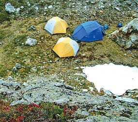 Our progress is slowed dramatically and becomes even more so when we are forced to either cross the river or bushwhack. The view is continually improving though, and our efforts are rewarded with a full view of the cirque. We sit and enjoy the moment, but with a lengthy return trip waiting for us, we turn back. We arrive back at the trailhead, completing the more than 10-mile trip as the sun disappears over the foothills.