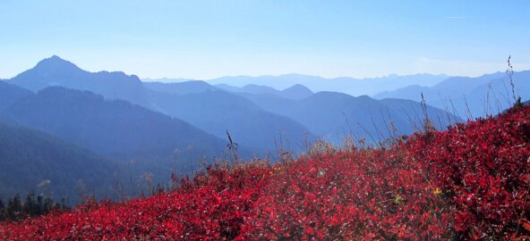
As the days become shorter and temperatures become cooler, biochemical processes begin to work their magic, transforming shades of green to a wide assortment of hues. This is when larch trees, berry shrubs, vine maples, alders and other deciduous trees display a riot of color for us to enjoy.
Beyond the eye candy, autumn is an ideal time to hike because the weather is cooler, the trails are less crowded and there are fewer insects.
Fall foliage in this region generally runs from mid-September through early November, although the vividness of color, when it shows up and how long it lasts is completely dependent on the kind of weather we receive before and during the season – specifically when it comes to temperature and moisture. Wet weather in early fall could inhibit color displays, but if we get a stretch of warm and sunny days with cool, above-freezing nights, we should be afforded an ideal show. Keep in mind, high elevations begin to turn before valleys and lowlands.
There are many hiking options to witness fall foliage, but here are a few suggestions to get you started.
Yellow Aster Butte
Yellow Aster Butte overlook elevation: 6,150 feet (1 ,874 m)
Yellow Aster Butte true summit elevation: 6,241 feet (1,902 m)
Total elevation gain: 2,550 feet (777 m)
Round-trip distance: 7.5 miles (12 km)
Driving directions: Take the Mt. Baker Hwy/East 542. About 12 miles (19 km) past the Glacier Public Service Center, turn left onto Forest Road 3065/Twin Lakes Road, which is just to the right of the DOT buildings. At the first junction, go left, and continue 4.5 miles (7.25 km) to the trailhead, which is at a tight switchback. There’s a privy at the trailhead. A Northwest Forest Pass is required.
This amazingly beautiful and understandably popular summer hike is even better in the fall. Just 1.5 miles (2.4 km) from the trailhead, views open up and they continue to improve all the way to the top. If you catch it at the right time, berry bushes will carpet the slopes with multiple shades of oranges and reds. Early fall, be on the lookout for deliciously ripe blueberries and salmonberries.
When you reach the overlook, you’ll have unobstructed, 360-degree views of high, craggy peaks, multi-colored meadows, twinkling tarns and lush valleys.
Adding to the color explosion, the nearby cliff faces and scree slopes of Mt. Larrabee provide veins of rusty oranges, reds and deep yellows. Tomyhoi Peak and the border peaks might even have dustings of snow, enhancing the contrast of the scene.
Johnson Ridge to Scorpion Mountain
Scorpion Mountain summit elevation: 5,540 feet (1,688 m)
Total elevation gain: 2,700 feet (822 m)
Round-trip distance: 9 miles (14.5 km)
Driving Directions: Take Hwy 2 east of Everett for about 50 miles (80.5 km). Roughly a mile (1.6 km) beyond Skykomish, turn left onto Beckler Road/Forest Road 65. Drive almost 7 miles (11.25 km) to a junction and take a hard right onto Forest Road 6520, just before going over Rapid River. In almost 3 miles (4.8 km), veer left, staying on 6520, and follow it for another 4 miles (6.4 km), then take a right onto Forest Road 6526, which leads to the trailhead, a decommissioned logging road at 3,700 feet (1,127 km). A Northwest Forest Pass is required.
Hike along this undulating ridge in the relatively new Wild Sky Wilderness, and enjoy sweeping views of colorful mountains, serene valleys and distant, jagged ridges.
Along your journey to Scorpion Mountain, you’ll pass through Douglas fir and hemlock forests, cross over 5,050-foot (1,539 m) Sunrise Mountain and traverse slopes that gleam with golden grasses and crimson-hued huckleberry leaves.
This hike has lots of ups and downs, including some steep sections, but if you can make it all the way to Scorpion Mountain, you’ll be rewarded with magnificent views of countless central Cascades mountains. As a bonus, you will have a commanding view of Joan Lake, sparkling 500 feet (152 m) directly below and just to your east. The rewarding views are wll worth the effort.
Lake Elan via Headlee Pass
Lake Elan elevation: 5,000 feet (1,524 m)
Total elevation gain: 2,700 feet (822 m)
Round-trip dstance: 7 miles (11.25 km)
Driving directions: From Granite Falls, take the Mountain Loop Highway (92) east. A few miles (5 km) past the Big Four Picnic Area, turn right onto Forest Road 4065/Sunrise Mine Road, and take this gravel road to the end (just under 2.5 miles or 4 km). A Northwest Forest Pass is required.
Nestled between Vesper Peak and Sperry Peak, Lake Elan, also known as Vesper Lake and Headlee Lake, is a small, turquoise-hued tarn surrounded by granite slabs, massive boulders and steep talus slopes.
On the drive in, just before the trailhead, you’ll get an intimidating view of Sperry Peak’s 3,000-foot (914 m) east face, as well as some golden pops of color at its base.
This challenging trail begins in the forest, but it soon opens up to a valley rich with reds, oranges and golds, which contrast wonderfully against the deep-green pine trees. Across the valley, ponder the cliff-clinging bushes and trees that complement the rock slabs.
Farther up, you’ll face the crux of the hike, the steep gully up to Headlee Pass. Beware of rockfall, and be careful not to kick rocks down onto unsuspecting hikers below you. If there is snow present, only proceed with the proper gear and training.
After a short dip beyond the pass, there’s just one more push up across a talus slope to Lake Elan. Even though this alpine lake lacks fall vegetation, it is incredibly beautiful, and its monochromatic shores will actually give your eyes some respite before heading back down for Act 2 of the color show. x