If you can see Mt. Baker, you are part of The Experience
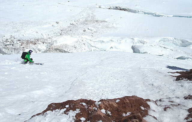 |
Technical descentSkiing the Nisqually Ice CliffBy Sam LozierWe skied a few hundred feet one skier at a time — and we would all watch anxiously as the next skier negotiated the glacial cracks that divided the route. Last winter, my phone rang out of the blue. The voice on the other end introduced himself as Joel from Colorado, a friend of a friend. We hadn’t met before, but he was planning on visiting this area and asked if I’d like to ski some “bigger backcountry days with him.” Since “ski as much as possible” is generally my game plan, I told him to call when he got to town. Fast forward a few months. Joel and his friend Josh were going to ski Mt. Rainier, and I was invited. A rainy drive from Bellingham got me to the south side of Mt. Rainier by 1 p.m., where I met Josh and Joel. We drove to the Paradise Inn, parked our cars and bought our climbing permits. With our paperwork completed, we headed up the mountain in light rain toward Camp Muir, an elevation of 10,080 feet. A cloud, similar to thick fog was blanketing the Muir snowfield, so we relied on a series of flags to make our way up much of the hill. Joel pointed at the line he wanted to ski, but clouds kept obscuring the view. It was at this moment that I thought I should ask what exactly he wanted to ski. “The Nisqually Ice Cliff,” Joel replied. I took a deep breath. The ice cliff route had been skied for the first time only a few weeks earlier. And while it certainly looked skiable, I knew there was probably a good reason why a line that visible from Paradise had not been skied until recently. After breaking out of the low clouds, we had about 1,000 vertical feet before arriving at Camp Muir. Camp Muir is a collection of tents, semi-permanent structures owned by the guiding companies, and permanent wood, metal and stone ranger cabins and latrines. It serves as the jumping-off point for most of the climbs up the south side of Rainier. We watched Camp Muir fade into darkness and the final glow of the sun slide off Mt. Adams, then cooked dinner and headed to bed. The next morning we awoke to a sea of clouds lapping at the cliffs below us with clear skies above. Despite the great weather, we were feeling sluggish and didn’t get out of camp until an hour after our intended departure time. Josh, and his friend Aaron, who joined us that morning, suggested we take the Gibraltar Ledges route up toward our intended ski line. Besides being more interesting, it was much more direct and allowed us to get a great look at the ice cliff before we committed to skiing it. We stopped for a snack at the Beehive, just before beginning the ledges portion of the day. Both Josh and I were feeling the altitude much earlier than we wanted. It looked like our late start, combined with our altitude-induced headaches and nausea, might cost us the summit and possibly even the line. Bits of rock were already melting out of the cliff above our intended ski line and clattering across the ice as we made our way up the Gibraltar Ledges. We clearly didn’t have a whole lot of extra time. I reached a point where nausea hit me worse than it had in a very long time, and I didn’t think I could go much further. I was more interested in staying strong and keeping my wits about me for the technical parts of the descent, so I rested while the others headed toward the true top of the run. We’d decided to forgo the summit since it looked increasingly like we’d get the choice of the summit or the Nisqually Ice Cliff, but not both. Since we’d gotten a late start and almost everyone was feeling slow, it seemed like a smart call. I waited while Aaron, Joel and Josh hiked to the top of the line, then I prepared to descend and traversed into the line as they skied down to meet me. Once we began skiing, most of our trepidation melted away. There were still plenty of things to go wrong, but the snow was about as perfect as we could have hoped for – enough of a soft top layer to ski confidently, but not so much that it was peeling off and sliding. Aaron and Josh led the way into the more serious part of the line. I was still feeling the altitude and was also hoping to focus on taking pictures, so it was quite a relief to have those two so eager to take charge. As we got into the meat of the route, the entire experience became completely surreal. The improbability of the great weather, surprisingly good snow and crazy setting kept hitting me every time we stopped to look around. We skied a few hundred feet one skier at a time, and would all watch anxiously as the next skier negotiated the glacial cracks that divided the route. It wasn’t all tension and worry though; there were hoots, hollers and high fives aplenty as we made our way down. Partway through the descent, as we realized everything else was working out, the question of the day became “How do we cross the bergschrund?” As we made our way closer and closer to the bottom, the bergschrund seemed to grow wider and more ominous until we rounded a final corner and saw, with relief, that a small snow bridge would connect us to the other side. We picked what we thought was the best route, jumped over a few small cracks and skied across the final snow bridge to the relative safety of the Nisqually Glacier. A few more high fives and we were on our way back to Muir to collect our stashed gear before skiing down to the car. We changed into more comfortable clothing before heading to the Copper Creek Tavern. We stuffed gigantic burgers into our faces and began to relax for the first time in more than 24 hours. My hunger temporarily stayed, I sped northbound toward my house trying to outrace my exhaustion. X Sam Lozier lives in the Mt. Baker area, where you can find him skiing, hiking, climbing, photographing and writing. Visit him at famousinternetskiers.com |


