If you can see Mt. Baker, you are part of The Experience
Many a hiker chooses to hang up their boots at summer’s end. However, committed trekkers know autumn hiking has its rewards: crisp air, vibrant foliage and deserted trails.
Fortunately, there’s no shortage of perfect fall hikes near Vancouver, BC. Here are three easy destinations for the shoulder season.
Reminders: Make sure to check current conditions, bring the 10 essentials, leave a trip plan with a responsible person, and remember to leave no trace. Dogs must be leashed on these trails.
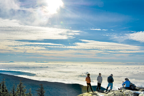 Dog Mountain
Round trip: 3.4 miles
Elevation gain: 430 feet
Access: On Trans-Canada Highway 1 in North Vancouver, north of Ironworkers Memorial Second Narrows Crossing, take Exit 22B. Head east on Mt. Seymour Parkway. Following signs for Mt. Seymour Provincial Park, turn left on Mt. Seymour Road and drive up to the ski area. Winter tires or chains are required between October and April.
The hike: Technically a shoulder of Mt. Seymour, Dog Mountain is a fine, family-friendly outing. It’s also a popular winter snowshoe trail. The hike lies outside the ski area boundary, so don’t make the mistake of buying a trail pass if you do go in winter.
Our loop begins at the BC Parks kiosk, near the bottom of the Mystery Peak Express chairlift. Saving the direct route to Dog Mountain for later, head north on the Mt. Seymour Trail (left of the Manning ski run) for a scenic detour to aptly named Dinkey Peak, our hike’s high point. After 0.3 miles, a left turn leads you up and down this mini summit with three viewpoints (spot your vehicle below?) to the First Lake Trail. Another left delivers you to First Lake itself, where you keep right to join the Dog Mountain Trail.
Continue west on the rooty path for 0.7 miles, popping out of the forest on a bluff with sensational views of the North Shore mountains, such as the Needles to the northwest, as well as Burrard Inlet (Tsleil-Wat to the Tsleil-Waututh Nation) and the urban sprawl of Metro Vancouver to the south. The elevation at Dog Mountain is 3,458 feet. The return trip involves retracing your steps to First Lake, where you keep right, sticking with the Dog Mountain Trail all the way back to the trailhead.
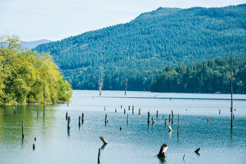 Hayward Lake
Round trip: 7.5 miles
Elevation gain: 215 feet
Access: From Highway 7 (Lougheed Highway) in Maple Ridge, go north on 287 Street, just west of the Stave River and Silvermere Lake. Continue onto Wilson Street and enter Mission. Turn right into the Railway Trail’s upper parking lot, 2.5 miles from the highway.
The hike: While the Railway Trail in Mission ostensibly offers a family-friendly outing, hikers and cyclists are cautioned against loitering in the section around Bob Brook. Dramatic signs warn of landslide risk heightened by heavy precipitation, with hazard ratings ranging from low to extreme.
Tracing a historic railway line, the 3.7-mile trail is located in the Hayward Lake Reservoir Recreation Area, part of BC Hydro’s Stave River hydroelectric complex. Impounded by the Ruskin Dam downstream from Stave Lake, Hayward Lake has filled a granite canyon in the heart of Kwantlen First Nation territory since the 1930s. Weather-beaten trestles recall the past, a version of which is highlighted by interpretative signs.
From the trailhead, drop down to the lakeshore and follow the wide gravel path northeast. There’s a little beach, and debris booms float in the cloudy blue-green water. Blackberry bushes line the path with power lines overhead. At intervals, the trail curves up and away from the shore to bridge a stream under the dappled light of Douglas fir and western red cedar trees.
After 3.4 miles on the Railway Trail, leave the slide hazard zone and turn left on Harry’s Trail. Round a pond in shade. At trail’s end, continue straight past a large parking lot and warden’s house to the beach (no dogs) with sand, picnic tables, and toilets. After lunch, walk southwest on the Railway Trail to return to the trailhead.
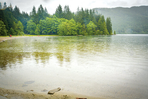 Hicks Lake
Round trip: 3.7 miles
Elevation gain: 150 feet
Access: From Trans-Canada Highway 1 (Exit 135), east of Chilliwack, head north on Highway 9 (Agassiz-Rosedale Highway/Hot Springs Road) to Harrison Hot Springs. Go right on Lillooet Road, which turns into Rockwell Drive, driving 4.3 miles to Sasquatch Provincial Park. Keep right on the gravel road to Hicks Lake Campground, before turning left to reach the day use area.
The hike: If you harbor a desire to cross paths with the Yeti, Ogopogo, or other mysterious creatures, Sasquatch Provincial Park beckons in the heart of Sts’ailes and Stó:l? territories, northeast of Harrison Hot Springs. Indeed, Sasquatch is an Anglicization of the Sts’ailes word Sa:sq’ets, which refers to the principal caretaker of the First Nation’s land.
From the day use area, walk south following the lakeshore. The Hicks Lake Trail crosses a dam and fish ladder (cutthroat trout spawn in March and April), skirts the popular campground, and comes to a sandy beach at the lake’s south end. Continue the counterclockwise loop on the east side of the lake. The Hicks Lake Trail eventually merges with a dirt road and delivers you back to the day-use area.
Several geocaches are stashed around the lake. Finding them requires a GPS receiver loaded with geocache data or a mobile phone with a geocaching app. Searching for geocaches (and their esoteric contents) in stumps, under tree roots and along the lakeshore is both a frustrating and fun way to double the length of time needed for this hike.
For more information on these and other hikes, check out Stephen Hui’s 105 Hikes In and Around Southwestern British Columbia, an all-new guide from Greystone Books. Visit 105hikes.com.


