If you can see Mt. Baker, you are part of The Experience
 Mt. Muller Trail 882, Olympic Peninsula
By Spencer Paxson
For a northwestern mountain biker, assembling a “Top-10” list of trails can be like trying to name the top-10 breaths of fresh air you’ve ever taken. It’s almost silly to rank anything so delightfully abundant. That said, it’s an amusing task at worst, and with so many good trails in this part of the world, any “Top-10” list is guaranteed to include some objectively fantastic trails for any type of rider.
Below is a brief guide to 10 classic mountain bike rides from the Fraser River Valley and Coast Range of British Columbia to the Central Cascades of Washington state. There are a few you may have experienced already. Others may be on your summer bucket-list, and a few may yet be unknown. Most are beginner friendly, but a few are expert-only. Whatever your riding style and skill level, hopefully this guide helps spark a memorable two-wheeled adventure.
Forbidden Plateau, cumberland, Vancouver Island, BC
~20 mile trail network, 2,300 feet elevation gain
Trail Stewards and Info: Cumberland Community Forest, cumberlandforest.com and cvmtb.com
Cumberland, B.C. has played host to the opening stages of the world-renowned BC Bike Race for the last several years. The Forbidden Plateau trail network above Comox Lake has been a mountain biking destination since the early 1990s. There is riding for everyone, from the beginner Bears Bait Trail, to higher-elevation rocky outcrops of Jake the Snake and Cabin Fever. Park at the Comox Dam and ride east on Comox Logging Road toward Boston Main and go from there. Warm up with a coffee at the Wandering Moose, or cool off with a dip at Nymph Falls after a solid day.
Sumas Mountain, fraser river valley, Bc
~50 mile trail network, 2,900 feet elevation gain
Trail Stewards and Info: Fraser Valley Mountain Bikers Association (FVMBA), fvmba.com
Sumas Mountain is one of multiple excellent trail networks in the Fraser River Valley of southern B.C. Just northeast of Abbotsford, there are nearly 50 miles of singletrack. Head up Sumas Mountain Road, park at the trailhead on lower Taggart Road and pedal up the road for more access. Beginners and seasoned experts alike will love the flow of the new Squid Line trail. More discerning advanced riders have lots to choose from. Be sure to hit up the viewpoint on the northeast corner of the network on Lookout Trail.
 Galbraith Mountain, Bellingham
Galbraith Mountain, Bellingham
~50 mile trail network, 1,800 feet elevation gain
Trail Stewards and Info: Whatcom Mountain Bike Coalition (WMBC), wmbcmtb.org
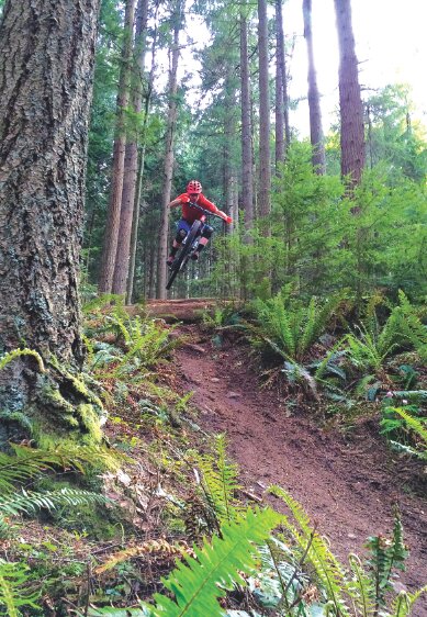
To most mountain bikers of northern Washington, the trails of Galbraith Mountain need no introduction. For over 30 years, the WMBC has stewarded this privately held land and developed a 50-mile network of serpentine, wooded singletrack. Two main trailheads are pedaling distance from town (one at Birch Street, the other at Galbraith Lane on Samish Way) and access predominantly beginner to intermediate trails. From twisty trails like Rock-n-Roll and Papa Bear to jumpy trails like Grasshopper and Unemployment Line, to plain old classics like Whoopsie Woodle and Orient Express, Galbraith is simply a great place to ride. There are literally hundreds of loop combinations. Afterward, roll back into town for a beer and bite at one of several Bellingham breweries.
Chuckanut Mountain, Bellingham
~15 mile trail network, 2,100 feet elevation gain
Trail Stewards and Info: Whatcom Mountain Bike Coalition (WMBC), wmbcmtb.org
Dominating the coastline south of Bellingham is the brawny Chuckanut Mountain. Accessed from multiple trailheads along Highway 11 (Arroyo Park, North Chuckanut Trailhead, Larrabee State Park), big climbs give way to scenic ocean views and gaping old growth forest. Chuckanut is also a good option for wet days, as it typically drains better than other trails in the Bellingham area. Climb up Hemlock Trail on the east side or Fragrance Lake and Cleator Road on the west side and ride Raptor Ridge or Double Black Diamond. On a clear day, take in the expansive east-facing views from the sandstone cliffs along Ridge Trail. If possible, finish with a definitive northwest tech experience on Salal and Hush Hush.
Mt. Constitution, Orcas Island
~30 mile trail network, 2,400 feet elevation gain
Trail Stewards and Info: Evergreen Mountain Bike Alliance, evergreenmtb.org
No quintessential Northwest tour is complete without a ride on a ferryboat. Luckily, there are many reasons to take a ferryboat (from Anacortes, WA) to access good riding on Orcas Island, including the trails of Mt. Constitution. Nearly 30 miles of trail are located within Moran State Park, with the best ones open from September 15 to May 15 every year. A great winter riding spot, beginners will be pleased with flat trails along Mountain Lake, and gravity-oriented riders will enjoy some air time on the Powerline Trail. Panoramic views and San Juan Islands serenity make for a unique and memorable day on the bike.
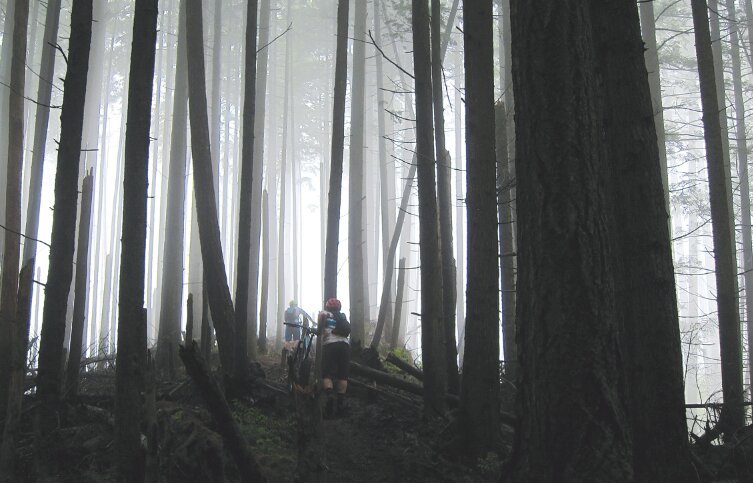
Mount Muller Trail 882, Olympic Peninsula
~13 mile loop, 3,100 feet elevation gain
Trail Stewards and Info: Pacific Ranger District and Evergreen Mountain Bike Alliance, evergreenmtb.org/trails/mount-muller
Mt. Muller is a lesser-known, adventurous trail located in the Olympic National Forest, about 30 miles southeast of Port Angeles on Highway 101. It is one of the few non-motorized trails in the Olympics that is open to mountain bikes. The 13-mile loop is for seasoned riders only, starting off with a 3.2-mile, 2,100-foot mountain goat climb from the trailhead on Forest Road 3071 on the north side of Highway 101. After the climb, head east on Trail 882 for the Mt. Muller summit at 3,748 feet, enjoy panoramic views of the Olympics, Strait of Juan de Fuca, and finish with a 6-mile descent back down to the highway. Hit this trail after the snow has melted out, and be mindful of hikers! Make a trip of it and camp at Klahowya Campground at Milepost 212.
 Tres Hombres, Leavenworth
Tres Hombres, Leavenworth
~9 mile loop, ~4.5 mile trail descent, 2,000 feet elevation gain
Trail Stewards and Info: Evergreen Mountain Bike Alliance, trailwiki.org/wiki/Tres_Hombres
Tres Hombres is a distinctive downhill trail that descends 2,000 feet of scenic, sage-scrub ridgeline above Derby Canyon. Located just a few miles outside of Leavenworth, this trail can easily be shuttled via Derby Canyon Road and Forest Road 7401. All of the jumps on Tres (and there are several!) have ride-around options, but there are mandatory steep rock faces that will demand confidence and speed control. The trail is best experienced on a full suspension trail bike, but expert cross-country riders should be able to manage with tall seats. Other great trails in this area include Xanadu (a scaled-down version of Tres Hombres) or the more beginner-friendly Rosy Boa trail. Visit the crew at Das Radhaus or Der Sportsman for trail info and directions.
Basalt Peak, Wenatchee National Forest
~15 mile loop, 4,000 feet elevation gain
Trail Stewards and Info: Lake Wenatchee Ranger District, evergreenmtb.org/trails/map/94
Another lesser known but prime northern Washington summer ride is Basalt Peak, also known as the Rock Creek area. Be warned, this route is for stalwart climbers and those who enjoy being well off the beaten path. Rock Creek is the only trail system in the Lake Wenatchee Ranger District that is closed to motorcycles but open to mountain bikes. Conditions are best in late summer to early fall (though the low snowpack of 2015 may yield earlier entry). Park at Finner Creek Campground 14 miles north of Lake Wenatchee on Chiwawa River Road. From there, bust out a clockwise loop up around the backside of Basalt Peak, and crest the top for monumental views from Glacier Peak to Lake Chelan.
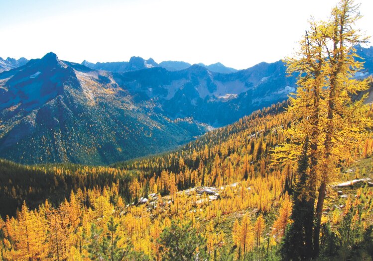
Angel’s Staircase, Carlton
~25 mile loop, 5,000 feet elevation gain
Trail Stewards and Info: Methow Valley Ranger District, evergreenmtb.org/trails/map/35
 Angel's Staircase, Carlton
Literally a pinnacle ride of northern Washington, the Angel’s Staircase loop in the North Cascades is one of the most fulfilling alpine bike rides imaginable. Once again, this route is for stalwart experts only, as it involves a testing combination of altitude, endurance, technical prowess and route finding. The loop starts off climbing Crater Creek Trail on Forest Road 300, about 2 miles past the Foggy Dew Campground. The wooded climb up Eagle Lake and Martin Creek trails brings you to the alpine cathedral of Cooney Lake, followed by a steep hike-a-bike to crest Angel’s Staircase at 8,000 feet. The ride concludes with a final steep climb over Horsehead Pass, and a highly gratifying 6-mile descent back to the trailhead. Good from late-summer to mid-fall, the best time is when the larches are in full bloom!
Greenwater Corridor (Hwy. 410), Greenwater
12-30+ mile trail system, 3,500-7,000 feet elevation gain
Trail Stewards and Info: Snoqualmie Ranger District, Evergreen MTB Alliance,
evergreenmtb.org/trails/noble-knob-dalles-ridge
The Greenwater Corridor is home to outstanding trails like Ranger Creek, Palisades, Noble Knob, Deep Creek and Sunset Peak. With multiple route options and fire-road climb options, this is a great trail system to introduce newer riders to the marvels of alpine riding. There is even a shuttle option available up Forest Road 7200/7250. That said, bring your climbing legs to achieve greater satisfaction and avoid blowing out the trails! Beginners will also enjoy testing their flow skills on the Skookum Flats trail. A typical route includes climbing up to Corral Pass and traversing out Noble Knob Trail 1184, then Dalles Ridge Trail 1173 to descend either Ranger Creek Tr1197 or Palisades Tr1198. Strong, motivated riders can put together big rides here with 10,000-plus feet of climbing. Plenty of nearby camping options make this area worthy of a full weekend of riding for anyone needing time in the mountains. x
Online Trail-Finder Resources:


