If you can see Mt. Baker, you are part of The Experience
Gorgeous scenery abounds in the North Cascades on both sides of the border. However, some epic trails may be a tad ambitious for parents with little ones.
Fortunately, we also have trails that are easy on effort and big on reward. Here are three delightfully kid-friendly hikes in Canada’s North Cascades.
Reminders: Check trail reports, bring the essentials, leave a trip plan with a responsible person and leave no trace.
Mt. Thom
Distance: 4.3 miles
Access: On Trans-Canada Highway 1 in Chilliwack, take Exit 123. Head south on Prest Road. Continue onto Teskey Way. Turn left on Jinkerson Road. Go right on Thom Creek Drive. Turn right on Sylvan Drive and find parking near the upper trailhead.
Trail: Mt. Thom is an enjoyable outing in any season. Our lollipop hike climbs the foothill from Chilliwack’s Promontory neighbourhood.
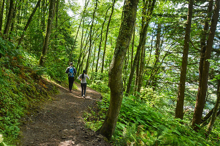 Hike to Mount Thom, B.C. August 8, 2020. Stephen Hui photo
From the kiosk on Sylvan Drive, enter Mt. Thom Park and climb 130 numbered steps. The viewpoint atop the stairs overlooks a suburban housing tract, the Fraser Valley and Chilliwack Mountain. Follow the Thom Creek Trail into the mixed woods. A path from MacFarlane Place joins from the right.
Go left at the Walker Creek Trail junction. Zigzag steadily uphill on the wide gravel path. Watch out for Pacific banana slugs and sideband snails underfoot. Lose some elevation.
At the Summit Bypass Trail junction, go right. The trail dips again. Climb 22 unnumbered steps. A bench offers a rest and a partial viewpoint. Keep right at signposts for Karver’s Trail, Churchill Parkway and the Ridgeline Trail, joining the Lookout Loop. Pass a bench viewpoint and follow a wire fence.
Finally, head up an eroded path to the satisfying summit viewpoint. Gaze southwest through the fireweed to Cultus Lake, Vedder Mountain and the Vedder River. However, the daring ravens are indubitably the stars of the show.
Continue left, turning right at a kiosk just downhill from the summit. Stroll among big old-growth Douglas firs. Go left on the quiet Ridgeline Trail. Skip the signed, but overgrown, viewpoint off to the right. Meet the Lookout Loop, closing the counter-clockwise summit loop; turn right and retrace your steps to Sylvan Drive.
Thacker Mountain
Distance: 3 miles
Access: Eastbound on Trans-Canada Highway 1, take Exit 170 in Hope. From the off-ramp, turn left. Go right on Old Hope Princeton Way. Make a left on 6th Avenue, followed by a right on Kawkawa Lake Road. Turn left on Union Bar Road, then make a sharp left on Thacker Mountain Road. Park by the end of the paved road.
Trail: Thacker Mountain stands east of the confluence of the Coquihalla River and Fraser River in Hope. A pleasant lollipop hike takes in the views from all sides of this forested hill.
From the cul-de-sac, start up the gravel service road. Keep left at a three-way junction under a rock wall and pass a yellow gate. Where a log lies by the roadside, a mossy bluff off to the left offers benches from which to admire the lovely view of little Landstrom Ridge and bigger Dog Mountain behind Hope and the Coquihalla-Fraser confluence. Keep kids back from the edge.
Continue up the road, which enters Thacker Regional Park and land owned by the University of British Columbia. After the road curves right, go left on a trail that rounds a wetland with a bridge over its outflow. Stay on the main trail as it bends right.
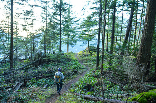 Hike to Thacker Mountain, B.C. December 8, 2019. Stephen Hui photo
Go left at a three-way junction to begin a clockwise loop. Detour left for a near-summit viewpoint, with an outcrop for sitting and snacking, which affords another grand perspective of Hope, the Fraser Valley and the Skagit Range. For a brief outing, turn around here.
Continuing the loop, pass a big Douglas fir, gradually descend and merge with an old road coming from the right. Walk the planks over the outlet of a wetland. Go left and up a side path, for a partial viewpoint overlooking Kawkawa Lake. Ogilvie Peak, Macleod Peak and Mt. Outram provide the backdrop.
The side path quickly rejoins the main trail. Hit the gravel road. Turn left and head up to the antenna tower. Go around the fence to score a big view of Hope Mountain from the cliff top. Kawkawa Creek, home to kokanee salmon runs, empties into the Coquihalla River below.
Head back down the gravel road, passing your previous path on the right and a gate on the left, and turning right on another path. By a pond, encounter the oddity locals call the bear tree. Kids will be drawn to the little cave underneath the pair of seemingly conjoined trees. Turn left at a junction from earlier to close the clockwise loop. Retrace your steps to the gravel road and down to the trailhead.
Lightning Lake
Distance: 5.6 miles
Access: From Hope, head east on Crowsnest Highway 3. At the Manning Park Resort, turn right on Gibson Pass Road. Turn left in 1.9 miles to reach the Lightning Lake day-use area.
Trail: It’s no mystery why outdoor enthusiasts flock to Lightning Lake in E.C. Manning Provincial Park every summer. The large campground is perfect for families, the lake holds rainbow trout, and the chilly bluish-green water makes for invigorating swimming. Another reason to visit is the rodents, namely the squirrels, chipmunks and beavers.
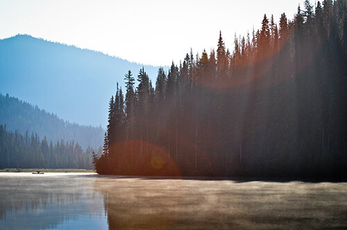 Camping at Lightning Lake campground in E.C. Manning Provincial Park, B.C. August 7, 2011. Stephen Hui photo
The whistled calls and burrows of Columbian ground squirrels welcome you to the day-use area. (Don’t approach or feed wildlife.) Start at the kiosk by the beach. Head east on the paved path and cross the dam at the end of the lake. The Frosty Mountain Trail quickly strikes off to the left. Stick with the easy Lightning Lake Trail to reach Rainbow Bridge, a postcard-worthy span over the lake’s narrows.
Don’t cross if you plan to circumnavigate the lake. Take a bridge over Lightning Creek immediately downstream of a beaver dam at the lake outlet. Turn right to stick with the loop trail. As you near Rainbow Bridge, scan for beaver-chewed trees along the shore and a beaver lodge across the water.
Follow the loop trail by Spruce Bay, the Lightning Lake campground, and around Lone Duck Bay to return to the day-use area. Sightings of black bears and mule deer are common. x
Stephen Hui is the author of “Best Hikes and Nature Walks With Kids In and Around Southwestern British Columbia,” a new guide to 55 family-friendly trails in B.C. and Washington. His first two books, “105 Hikes and Destination Hikes,” were #1 B.C. bestsellers. Learn more: 105hikes.com


