If you can see Mt. Baker, you are part of The Experience
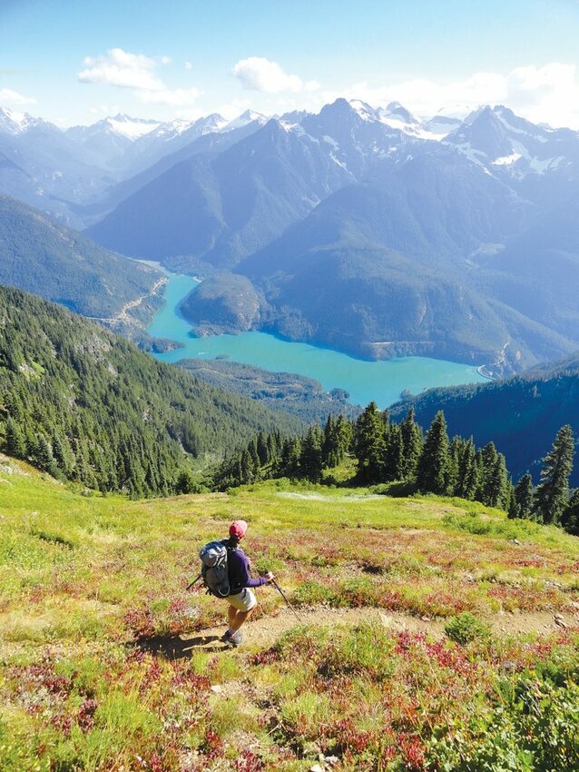 The view of Diablo Lake from Sourdough Mountain.
The North Cascades National Park complex contains some of the largest roadless tracts remaining in the lower 48. Stunning views, lofty summits, sparkling alpine lakes, thundering waterways, sublime wildflowers, prolific wildlife, primeval forests, and more than 300 glistening glaciers grace the park’s nearly 700,000 acres.
This raw and untamed wilderness offers some of the absolute best hiking and backpacking in the country. Here are three of my favorites – one moderate, one difficult and one challenging day hike or moderate backpacking adventure – to get you started exploring this vast and breathtaking region.
Distance: 10 miles roundtrip
Elevation gain: 1,000 feet
Trailhead directions: Take Lady of the Lake passenger ferry from Chelan to Stehekin.
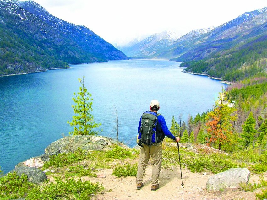
The only substantial trail embracing Lake Chelan’s 50-mile-long, fjord-like dramatic shoreline, the Chelan Lakeshore Trail stretches 17 miles from Stehekin to Chelan. A short but satisfying hike from Stehekin to Hunts Bluff shows off the northern portion of this trail. Along the way you’ll traverse sun-kissed ledges and forested ravines cradling cascading creeks. Renowned for its prolific wildflowers (and rattlesnakes), this trail is best done in spring.
Start by taking the Lady of the Lake ferry from Chelan to Washington’s remotest community, Stehekin. Find the trailhead near the Golden West Visitor Center. You’ll pass some cabins and soon traverse the first of two fairly recent burn zones, where the trail undulates between greenery and ghost forests.
The trail skirts a few cabins before reaching wilder shoreline and eventually a ledge granting an excellent view south down the lake to Domke Mountain Continue along the scenic shoreline before once again climbing above and away from it – a pattern repeated frequently. Pass an old rock wall and compound, cross Four Mile Creek, then follow Click Creek into a little chasm.
Next emerge on a high bluff with a view back to Stehekin with 7,161-foot Purple Mountain rising above it. Pass the Flick Creek Campground and shelter, (or spend the night if you have a permit) then start a long ascent. Cross Hunts Creek in a deep ravine before emerging on Hunts Bluff 600 feet above the lake. Enjoy spectacular views up lake to Stehekin and McGregor Mountain and down lake to Moore Point. Scan the lake for loons, and the sunny ledges for blossoms.
Distance: 11 miles roundtrip
Elevation gain: 5,100 feet
Trailhead directions: From SR 20 turn north onto Diablo Road, 5.3 miles east of Newhalem. Then proceed 0.6 miles to the trailhead.
It’s an absolutely arduous ascent to the historic 1933 fire lookout atop Sourdough Mountain. One of the most challenging day hikes in North Cascades National Park, you’ll climb nearly one vertical mile in 5.5 miles. But a priceless panorama of craggy, spiraling, glacier-cloaked, cloud piercing, unbelievably breathtaking peaks is the payoff and Diablo Lake’s sparkling surrealistic turquoise-tinted water directly below is an added scenic dividend. I first hiked Sourdough Mountain in the summer of 1985 – my very first hike in the North Cascades National Park. I have returned frequently, never tiring of the views and challenge.
The trail starts at 900 feet elevation and wastes no time heading for the heavens. Utilizing tight switchbacks, the trail relentlessly gains more than 3,000 feet in the first two miles. At about 4 miles, Sourdough Creek’s cascading waters greet you at a pocket meadow. The grind is over and an incredible journey across wildflower-saturated meadows begins. Unfortunately, many ill-prepared and unfit hikers never make it to this point.
Begin traversing sub-alpine forest groves and sprawling meadows. Pause frequently to catch your breath while marveling at in-your-face views of Ruby Mountain, Pyramid Peak and Colonial Peak with its massive glacier. But it’s Diablo Lake twinkling one mile directly below that’ll blow you away.
After switch-backing through those heavenly meadows, the trail darts across the broad summit ridge. Here, a restored 1933 fire lookout – once staffed by beatnik poets Gary Snyder and Philip Whalen – greets you. You’ll no doubt wax poetic while absorbing the natural beauty. A serrated sea of glistening ice and craggy summits surrounds you dominated by 9,075-foot Jack Mountain. The view is worth returning to over and over again, despite the 5,000-foot vertical climb required to reach it.
Distance: 18 miles roundtrip
Elevation Gain: 4,550 feet
Trailhead Directions: From SR 20 in Marblemount, turn east onto Cascade River Road and follow it 23 miles to its end.
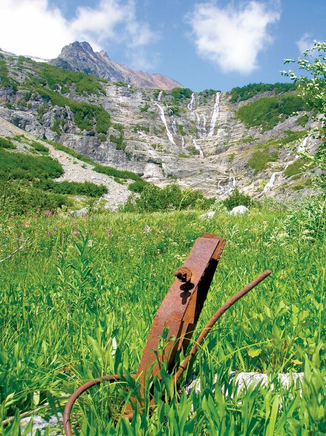
Cascade Pass is one of the most popular hikes in the North Cascades National Park. With its well-graded trail leading to stupendous views, how could it not be? Trade your daypack for an overnight pack (be sure to get your permits) and push a little farther beyond the pass to discover one of the most awe-inspiring cirques in the state, Horseshoe Basin. It sports a historic mine and sprawling meadows fed by a half-dozen towering waterfalls.
Start your hike by switch-backing some 30 times up steep slopes. After climbing 1,400 feet in two miles, the grade eases, making a long traverse toward Cascade Pass. Long used by Native Americans, explorers, prospectors and surveyors, this pass was a wise choice for passage through the nearly impenetrable North Cascades. Reach the 5,400-foot pass and savor the views, especially the formidable wall of peaks to the south. Then get ready to soak up some serenity as most of your fellow hikers turn around or head for Sahale Arm. Drop into the Pelton Creek Basin, a hanging valley of cascading waters tumbling down icy walls. Pass Pelton Basin Camp or set up here for the night.
The way now teeters along a headwall offering views to 8,122-foot McGregor Mountain towering over the Stehekin Valley. Continue descending. Doubtful Creek may have you doubting how to cross as it careens over a polished ledge. At 7 miles, reach the Horseshoe Basin Trail. If you plan to camp at Basin Creek, continue right for another half-mile to set up camp, then return to this junction to explore the basin.
Hike into the amphitheater-like basin and admire fields of swaying grasses and dancing flowers set beneath no less than a half-dozen silvery strands of tumbling creeks. Cock your head back and marvel at the sheer walls capped with hanging glaciers: one of the most impressive sights in the Cascades. Old mining relics from the Black Warrior Mine lie littered among the blossoms and boulders. The mine, bored deep into the face of the cirque, operated until the late 1950s. Now on the National Register of Historic Sites, the mine can still be explored, but don’t venture beyond the shaft’s entrance. The view from the shaft out over the Basin Creek Valley to Trapper Mountain is just as impressive as the views of Horseshoe Basin from the valley floor.
For detailed information on these hikes, consult Craig Romano’s “Day Hiking North Cascades” and “Backpacking Washington” guidebooks.
Craig Romano is an award-winning author of more than 20 guidebooks with Mountaineers Books. He has hiked more than 20,000 miles in Washington state from the Olympics to the Blues.


