If you can see Mt. Baker, you are part of The Experience
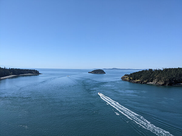 Deception Pass from the bridge.
With winter upon us, our hiking situation has changed. Snow in the Cascades makes access to many of our favorite trails inaccessible or into a snow sport. Short of strapping on some cross-country skis or snowshoes, Mt. Baker’s most iconic trails are cut off from a typical hike with the path buried deep below the snow’s surface. For those who like to get out and wear the trails out, this can be a challenging time of year while looking for other ways to stay active in our grayer months. Well, worry not. There are plenty of lowland options to get you through the winter.
These three hiking areas offer easy access, a plethora of options and views to reward the effort. With varying elevations, some may encounter a dusting of snow, but nothing like the regular dumping some of our higher hikes see. From the shores of our waterways to tucked away lakes, these options can give you that hiking fix while you wander the woods and discover perched-up views of our winter wonderland.
Deception Pass State Park
Distance: Two level hikes go along the water. Cranberry Lake Trail is approximately 1.5 miles from the welcome station to West Point. From there, the North Beach Trail is .9 miles before another approximately .5 miles up to Deception Pass Bridge.
Access: Take I-5 exit 230 and head west on Highway 20 for 17 miles. You can’t miss it when you hit Deception Pass.
The gateway to Whidbey Island, Deception Pass, is known for its stunning view while crossing the bridges on either side of Pass Island, but what often goes unnoticed is the miles and miles of trails the state park has to offer.
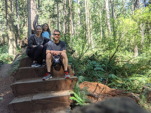 The Moceri family stopped on Deception Pass Trail.
The network of trails on either side of Highway 20 winds you through coastal forests and along beaches lapped by fresh and saltwater alike. While there is some up-and-down terrain, most of the hiking is moderate to easy, with the strenuousness of the hike determined by the distance. On the Whidbey Island side of the park from the northern point, you start with views of Deception Pass and can walk on the bridge. This parking lot is often busy, but there are other parking lots to go to farther in the park. Heading east on the Goose Rock Perimeter Trail, you can get a high view of Cornet Bay.
The trail system on the east side of the highway will lead you to the quarry pond and eventually all the way around until you reach the highway again. On the west side of the highway, you will be greeted by Cranberry Lake, which has its own set of trails offering views of the lakes and access to campgrounds. A sliver of land separates the westerly part of the lake before you reach the salt water. From here, you can once again test out part of the Pacific Northwest Trail or, depending on the tide, walk right along the beach.
Looping around the west point, you will be back on North Beach with a clear view of Deception Pass and the bridges above. Eventually, a winding trail will lead you back up to the parking lot and bridge. With miles of trails and beaches to walk, this essentially sea-level hike can be a long day of exploring every nook and cranny or multiple trips to discover something new.
Squires Lake and the Alger Alps
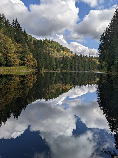 A view of Squires Lake.
Distance: Squires Lake Loop – From the parking lot to Squires Lake is .3 miles of moderate uphill before reaching the 1.1 mile loop around the lake.
Alger Alps from Alger Cain Lake Road – With 1,150 feet of elevation gain, this 4.4 mile round trip hike will get you up to a height of 1,272 feet.
Access: Squires Lake parking lot – Take I-5 exit 242 and turn east on Nulle Road. Nulle Road will loop around and turn into Old Highway 99. From that point, you have .3 miles and the parking lot will be on your left.
Alger Alps South Route – Go past the Squires Lake parking lot and turn left onto Alger Cain Lake Road. From there, the U.S. Forest Service will be on your left-hand side in .25 miles.
There is a network of trails in Alger that can have you wandering in the woods for hours, or you can bite off smaller pieces at a time. Squires Lake, located off Old Hwy 99, has a parking lot at the base of a winding trail leading up to the lake itself. At this point, there are a series of loops that can be done depending on how much of a hike you want. The larger loop around the lake provides views of the lake from most points of the trail. A couple of other loops give you more time amongst the trees or up to a beaver pond.
If you are in for a little more elevation gain, you can continue past the beaver dam trail and head up toward the Alger Alps. This is a steep trail leading to an overlook where you can see all the way to the bay. This is an out-and-back hike unless you leave a car or bike at the other access point to the trail system. There is no parking lot, but with ample shoulder to pull off, you can leave a vehicle on Alger Cain Lake Road to make this a potential thru-hike.
From the Alger Cain Lake side, you begin by walking up a logging road past a few homes before being fully immersed in the woods. This route is a steady uphill without alternative routes until it reaches the junction from Squires Lake. If you do choose to do the thru-hike, you can pride yourself in knowing you did a piece of the Pacific Northwest Trail, which is a 1,200-mile trail from Glacier National Park to the Pacific Ocean in Olympic National Park.
Little Mountain Park
Distance: From the entrance of the park to the upper viewpoint is 1.5 miles with 934 feet of elevation gain. The park is made up of a series of short trails ranging from the Bonnie & Clyde Trail of one mile down to the Viewpoint Walkway Trail of .05 miles, which is ADA accessible. In total there are 10.13 miles of hiking-only and multi-use trails. The park also includes mountain bike-only trails.
Access: From I-5, take exit 225 in Mount Vernon and head east on Anderson Road. Anderson Road turns into South Laventure Road. When you reach E Blackburn Road, turn right then turn right on Little Mountain Road and head up the hill until you reach the park entrance.
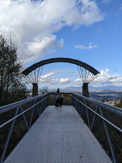 Little Mountain Overlook.
Little Mountain Park is only little in name. East of I-5 in Mount Vernon, this park, while at nearly 1,000 feet, should be free of snow most of the year. From paved paths to winding trails, this mountain is a choose-your-own hiking adventure. Parking at the base will provide a good climb, sure to get the heart rate up and the muscles burning.
If you choose to drive to the top of the paved road, the upper parking lot offers outlooks accessible to everyone. While you may have some company, the outlooks on opposite sides of the mountain offer differing views of Skagit Valley all the way to the water. Meandering trails along ridges provide different perspectives and a little more solitude as you wander through the trees, occasionally discovering new spots to peak out. The cell phone tower can seem like the end but push on past to find another network of trails.
There are ample parking and excellent maps to help you plan out where to go and how much distance to travel. I took a picture of the map so that I could pull it up while wandering around. Paths crisscross a bit, and some go on and on while others abruptly tie into another route. At one point, slightly turned around, I asked who looked like an experienced Little Mountain Park hiker where to go, and he was happy to lay out my options for different paths. x
Tony Moceri is a freelance writer who loves to get out and explore the world with his family. He shares his journey @adventurewithinreach and tonymoceri.com.


