If you can see Mt. Baker, you are part of The Experience
Historically, in order to escape from daily life and technology, one could go to the mountains. Now, with technology all around us, the ability to escape seems more difficult. While that has a downside, mountain technology is getting better every day and it’s hard to ignore its usefulness. To help you decide what to leave at home and what to bring, here is a guide on tech for your next trek.
The ability to communicate from the mountains is the biggest change that’s taken place over the last 20 years. This ability – both with cell phones and with other devices – has radically increased the speed at which rescues can take place. It has also changed the nature of how we communicate with one another in the mountains. For better or worse, we’re no longer completely unplugged.
Cell phones – Cell phones should not be counted on for emergency use. But occasionally when it appears you don’t have service but still try 911, service will magically appear. That’s because cell phone providers work together to provide emergency services. The ability to access the internet when possible can also increase your safety because you can get up to date weather and avalanche forecasts, as well as trail and route information.
Satellite phones – These are pricey with the least expensive options running $600. More commonly, they’re about twice that. And then there are the satellite phone plans, which commonly cost between $1 and $2 a minute. The phones are not cheap, but if you are looking for the best way to ensure you get a call out, these could be your best option.
UHF/VHF radios – These ham-style radios can be “opened up” to allow users to talk on frequencies outside the amateur radio bands. It is illegal to do this, but nobody will prosecute you if you use a band outside of the ham bands in an emergency.
BaoFeng radios – These radios are popular with mountain guides and usually run between $100 and $200. Models with more options from Yaesu or Kenwood are $300 to $500. UHF/VHF radios are complex and to legally use them, one must complete a ham radio license test (approximately $15 and can be taken at Whatcom County Search & Rescue). They can be used in emergencies high in the mountains, but do not work well in valleys.
FRS radios – Family Radio Service radios are the common two-way radios you see all over ski areas. These are person-to-person, line-of-sight radios that are great for skiing, rock climbing or backpacking. At $30-$100, they’re inexpensive and can be purchased almost anywhere. The downside is they have limited use in emergencies.
If you spend a lot of time in the backcountry and participate in risky activities like backcountry skiing or climbing, it’s hard to justify not owning one of these in 2018.
Personal locator beacons – These are often referred to as the “yuppie 911” by the National Park Service, since some groups have used them for such non-emergencies as their water not tasting right and have become standard equipment in the backcountry; SPOT and DeLorme inReach are two popular models.
The primary use of these devices is to call for help. They notify 911 that you’re in trouble and provide an exact location to emergency services. Many models have additional capabilities too – some Bluetooth to smart phones and provide both texting and GPS capabilities and others provide that right within the device.
Personal locator beacons cost between $150 and $400 and require a subscription. If you spend a lot of time in the backcountry and participate in risky activities like backcountry skiing or climbing, it’s hard to justify not owning one of these in 2018.
For many years the only way to adequately use a GPS in the mountains was to buy an expensive GPS unit – that has changed radically. Yes, you still can buy a device, but you can also download an app for your smartphone.
The most popular GPS app with mountain guides is Gaia. This app – which retails for $20 – syncs with your computer automatically so that you can plan routes on your smartphone or your laptop. It doesn’t need to be within cell range and works in airplane mode. However, you need to download maps to your phone before going into the backcountry.
Smartphone GPS apps have two downsides. The first is that if you use breadcrumbs features, which constantly send your location back to the app, it will drain the battery quickly. The second is that smartphones can be harder to use in harsh weather. Gloves often don’t work on touch screens and water ruins phones.
There are tons of ancillary apps that can be helpful for navigation, including mountain identification apps that use your camera (like Peak.AR or PeakFinder) as well as several variations of altitude and compass apps.
I spend a lot of time in the backcountry and I read a lot and so the ability to download books to my phone is a game changer. My pack weight dropped and books for entertainment are only part of the equation. I no longer carry a little first aid book; now I have a backcountry first aid textbook. I also carry books on plant identification as well as books on animal tracks. I have a whole library of backcountry knowledge on my phone.
Some people download films, video games, music and podcasts. If you go on expeditions and log a lot of tent time, it’s worth figuring out what other entertainment you can fit on your phone.
I have a Suunto Ambit3 watch, which does a bit of everything. It operates as a GPS, has an altimeter and a barometer, as well as the ability to download watch-specific apps that do all kinds of things. I also wear an avalanche transceiver when I backcountry ski.
There are tons of backcountry, skiing, climbing, weather and avalanche apps that I haven’t hit upon here as well as other devices ranging from drones to headlamps that Bluetooth to your phone. It’s all out there, so look around a bit and find what’s right for you.
Batteries, especially cell phone batteries, tend to run down quickly in the backcountry. To preserve battery power, keep your phone in airplane mode when not actively trying to make calls. As long as you downloaded your maps ahead of time, your GPS apps should continue to work when your phone is in airplane mode. And finally, don’t let your phone get too cold – cold weather saps batteries.
On short trips, portable chargers make a lot of sense. I like the Goal Zero Flip 10 (one full charge) or the Goal Zero Flip 20 (two full charges). There are a few larger battery packs on the market, but they don’t seem to provide the three or four charges they claim to.
The USB cables that come with these chargers tend to be short, and for good reason. Longer cords tend to “leak” power between the charger and the device. To be really efficient, get a short cable.
If you use a solar panel to recharge your device, don’t connect it directly. If the solar panel isn’t getting direct sun, the panel will actually drain the device rather than charge it. Instead, connect the solar panel to a battery charger and recharge the charger. If the charger was designed with solar panels in mind it won’t allow the panel to drain energy.
You may read this article and roll your eyes, muttering, “The last thing we need is more technology in the backcountry,” or “I go to the mountains to get away from this stuff.” And you aren’t wrong. Technology needs to be used responsibly. If your technology negatively impacts someone, you should put it away, enjoy the view and use the technology once you’re away from others.
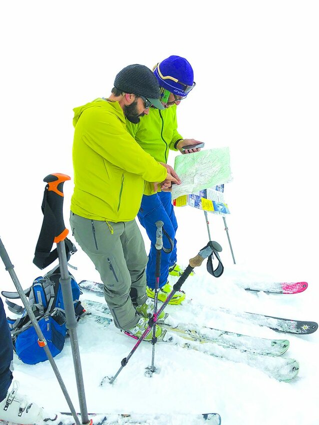
No matter what you decide about technology in the backcountry, remember to not place all your trust in electronics. Carry a map and compass and have a plan if your communication system breaks down.

Jason D. Martin is a mountain guide, general manager at American Alpine Institute and a widely published outdoor writer. He lives in Bellingham with his wife and two young children.


