If you can see Mt. Baker, you are part of The Experience
 | ||||||
Exploring the little-known mountain bike trailsStory and photos by Ryan Hasert Chances are if you’re a mountain biker, you know the Whistler Bike Park, located just a few hours’ drive north of Vancouver. When the snow melts from the world-famous ski resort, it quickly transforms into a mountain bike haven equal to its reputation for skiing. The lifts shuttle up hundreds of gravity-seeking riders every day during the summer months; however, unbeknownst to many, there also lies a large network of trails outside the bike park’s domain.
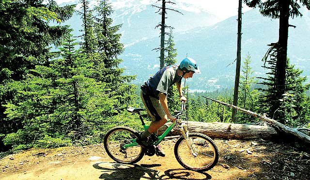
After an unusually hot day in Whistler, with temperatures nearly reaching 90°F (after months of wet, cold rides I certainly was not complaining), I decided to take advantage of the cooler evening to ride. Before I knew it, I was at a nondescript entrance off a paved road that apparently marked the trail Cut Yer Bars. My tires transitioned from the pavement to familiar dry, hard dirt. I began my ascent and followed the twisty trail over rocks and roots. As I continued upward, alternate routes began to appear on either side, most leading to more advanced and technical climbs. I reached the apex of the ridge and was rewarded with a similar set of options for descent. Any combination of right hand turns in the trail led to increasingly advanced trails, while staying left made for a safe bet. Holding true to my desire for exploration and remembering the bike park’s descents, I angled the bars to the right to see what was in store. The track immediately became more technical and soon began to pitch downward. I was met with rolling rock features, large roots and steep singletrack. Quickly picking up speed, I flowed through foreign trail. The periphery blurred, and my focus was intent on what lay next around every corner. Just as nonchalantly as it had started, it ended. I was quickly spit back out on the road I had started on. Heart racing and a smile etched on my face, I looked back on the hillside, amazed at what a gem I had found, with a new eagerness for the trails that I wanted to ride next. I awoke the next day with my sights set on a more ambitious ride – the Rainbow-Sproatt Flank trail. Nearly 30 miles long, the trail spans two peaks opposite the resort. The horizontal stretch of the Flank trail also marks the beginning of several downhill trails that lead back to the valley floor, providing a tempting relief from the many steep climbs strewn throughout the Flank. In an attempt to get right into the middle of the trail, I intersected the Flank from the Rainbow Park junction that meets near the trail’s middle. I was met with a steep road grade that persisted for the first mile or so. Cranking into my lowest gear with legs already burning, I pedaled onward. It was mid morning, and the temperature seemed to be rising faster than I was. Whistler Village began disappearing beneath me. To my great relief, the road grade transitioned to winding single track. I was brought through open shale fields, tight forests and exposed rock slabs – a variety of terrain that is best experienced with a mountain bike.
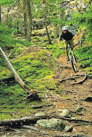
I decided to cash in on my gained elevation and dropped into Cheap Thrills. I shifted up into higher gears and coasted forward. True to its reputation, the trail dropped away quickly. Already feathering my brakes over loose dirt and rock slabs, the trail began to push my comfort level after just a few moments. Steepness engulfed my bike, and like a swift-moving river, carried me continually downward. My brakes did little to slow me down and I had to choose my line quickly, without a second thought. Cheap Thrills could certainly come at a high cost if any slight mistake was made. Maneuvering over the ladder bridges, multi-stage rock rolls, and steep pitches made for an exhilarating, quick descent. Arms, legs and heart pumping in rapid unison, I continued down the road past Alta Lake to pick up the River Runs Through It trail to wrap up the day. River Runs Through It is a winding and twisting trail with not much elevation gain or loss, but it is characterized by the many ladder bridges, stunts and log rides that it has to offer. It became a test of balance and concentration as I wove my way down the trail, marveling at the creative construction. After a dizzying amount of turns and loops, I soon popped out onto the road and headed back into town. I rolled through the village, passing riders with lift tickets and season passes hung around their necks. Arriving at the base of the lift, I sat and watched hordes of riders come down the beaten trails, their bikes chattering with mechanical pain. I overheard the typical complaints of the deteriorating conditions: washboards, blown out corners and crowded trails. Smiling to myself, I could not relate – I had solid corners, fresh dirt and few people. Not to mention I had only ridden just a few of the many trails available. A quick glance over my shoulder toward the mountainsides I had just ridden, and I knew I would not be buying another lift ticket any time soon. X Ryan Hasert is an avid mountain biker, skier, hiker, photographer and writer. Visit him atnorthwestperiphery.com.
|


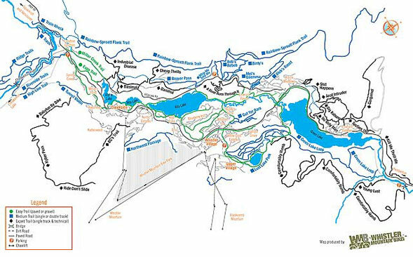
 After years of riding the bike park, I had heard of the famous (and infamous) valley trails that wind throughout the town and nearby foothills. Certified by WORCA (Whistler Offroad Cycling Association), these trails are fully legal and endorsed by the city – an open invitation to some of the best all-mountain riding in the Northwest. Although initially reluctant to forgo endless lift-access laps in the bike park, I grabbed a map at the Whistler visitor’s center and set out to see what I could find.
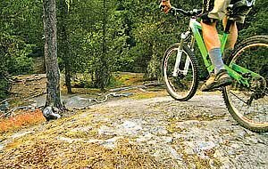 I reached a clearing, stopped and noticed another trail entrance. No distinct markings, no trail sign. This was becoming a common theme among these valley trails. Perhaps this is the reason why so few people ride them? Nevertheless I pulled out the map, and after narrowing down my location, concluded that I had arrived at the start of Cheap Thrills – a downhill trail known for its technical descent and rock rolls.