If you can see Mt. Baker, you are part of The Experience
 Bruce Bjornstad photo
Hanford Reach is a place of wonder.
Such as, I wonder why bank swallows never make their nests in cliffs? And vice-versa?
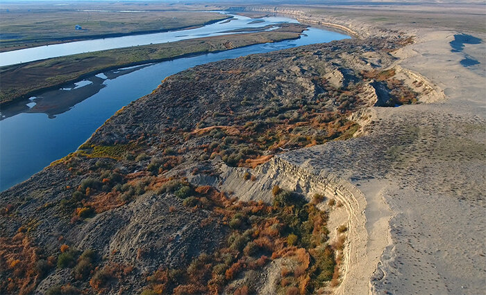
Floating the last open stretch of the Columbia River offers acres of time for stray thoughts such as that. This is a land of deep time: Old-growth sagebrush (yes, there is such a thing) lines the eastward shore. The Columbia itself carries glacial meltwaters from Canada that pre-date the Roman Empire. The salmon that reach this point are pursuing a natural odyssey 20,000 years old. Most of the stretch shows no sign of modern civilization, such as it is, until you drift in sight of the Hanford nuclear monoliths, which seem otherworldly anyhow, possibly artifacts of long-ago alien landings.
I’m perambulating downstream in a canoe on a placid early summer morn, and “deep time” describes the day itself perfectly. No need to hurry, and attempts to do so (i.e., paddling hard) would not improve much on the river’s mighty flow.
So it’s not weird at all that I find myself wondering when the swallow evolutionary path hit a divergence in which one branch cast their lot with mud-daub colonies on cliffs, and their cousins decided to focus on long burrows in the sand and clay of riverbanks. Was that a million years ago? Did it happen right here? Is that why there are vast colonies of both swallows to admire, their nests tunneled into the glacial till and volcanic ash of the Columbia Basin lowlands — or cantilevered onto the chalk cliffs riding over undercut turns?
 Bruce Bjornstad photo
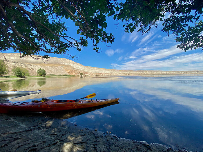
As adventure goes, this float is meditative more than mercenary, but there’s great virtue in that. A canoe is a perfect conveyance, too, practical, casually elegant, easily aimed and welcomed by the river itself, which has seen cottonwood versions of my craft for thousands of years, their indigenous paddlers heading downriver to trade elk hide for abalone shell.
This area, and the river within, is a U.S. national monument, controversially saved by President Bill Clinton from local ag interests who wanted to turn it into apple orchards.
Instead, now it’s still the home of the biggest sagebrush on Earth. The indigenous Columbia Basin big sage can grow past 8 feet (that’s a big sagebrush, folks), and hiking in a sage forest is a unique experience, especially aromatically. But most people travel the preserve by floating the Hanford Reach — its 51 miles north of Richland the Columbia’s last free-flowing stretch in the U.S.
You can do both, of course: Put your canoe in just below Priest Rapids Dam at Vernita Bridge, pack a lunch, drift a few hours, pull off at a sandy beach for lunch and stretch your legs in the sage forest. Then, back in the water, you’re going to spend most of the day marveling at the Reach’s greatest abundance, birds. Thousands upon thousands, representing almost every riparian species imaginable: ducks, geese, swans, scoters, cormorants, herons, pelicans, loons, gulls, curlews, killdeer, sandpipers, kingfishers. Up the banks: harriers, magpies, blackbirds, ravens, meadowlarks, kestrels, eagles (ho-hum) and ospreys. Hardly anywhere in the U.S. affords the opportunity to see more different birds in one day than here.
But there’s more. Deer ghost through the sage. Porcupines dangle from cottonwoods. Elk graze the dry grass of the eastern shore, having migrated down from the Cascades years ago to assert their ancient legacy as animals of the wide-open plains.
Here, too, the river itself asserts its identity as one of the geographic behemoths of America. Its springtime flow, 273,000 cubic feet per second, makes it the third-largest river contained entirely inside the U.S. Long ago dammed for electricity (yay, plasma-screen TVs), the Columbia provides close to half of U.S. hydroelectric power. Thus, most of its American length consists now of reservoirs or tidal reaches; the Hanford Reach is a preserve that preserves both a landscape and a character. Though it’s quite safely manageable for recreational paddlers, the boils and sweeps at big bends make you think of undersea monsters struggling to escape.
We humans travel the Columbia’s back as guests, not masters, to use an outdated term that underlaid our transformation of the rest of the river into a series of lakes. “Down her wild mountains and canyons she flew,” Woody Guthrie sang of the river in a 1941 song ironically commissioned by the government to celebrate the biggest dams of all, Grand Coulee and Bonneville.
“Roll on, Columbia, roll on/Your power is turning our darkness to dawn,” Guthrie rhapsodized. True enough, but riding the river down toward the sea, as Guthrie sang, spurs wistful thoughts of what was but will never again be.
The flow is absorbed into lake again by the time you reach Richland. Most paddlers don’t go that far, hauling out at White Bluffs, 19 miles below Vernita. It’s a seven-hour journey, unless you measure it by spiritual time, which is utterly infinite. x
Eric Lucas lives on a small farm on San Juan Island, where he grows organic hay, beans, squash and apples. For more information on Hanford Reach, visit fws.gov. Trailnot4sissies.com


