If you can see Mt. Baker, you are part of The Experience
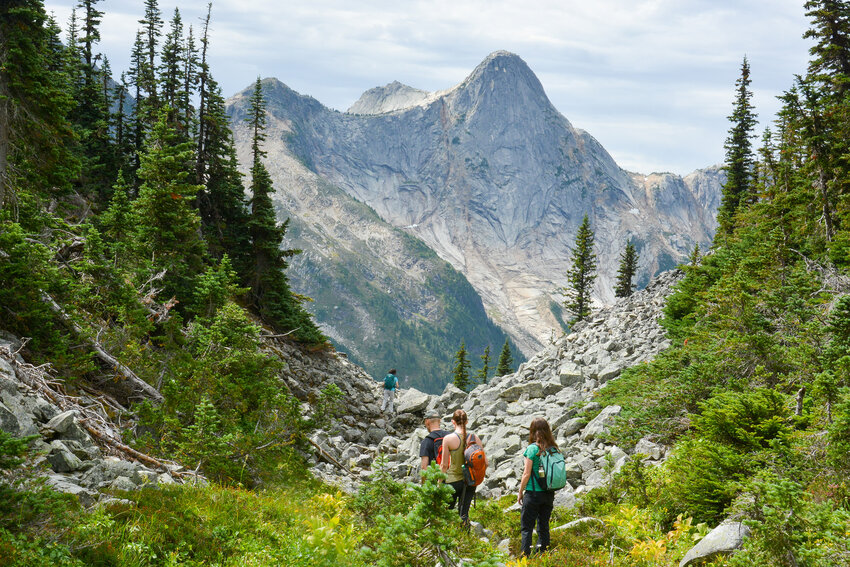 Hike to Zoa Peak, B.C. August 31, 2019. Stephen Hui photo
The fact that hikers flock to wildflower meadows like kids to an ice-cream truck may seem strange to the uninitiated. However, once you’ve glimpsed the kaleidoscopic blooms of the subalpine in summer, there’s no turning back.
Fortunately, the North Cascades have no shortage of trails offering admission to the annual flower show. Here are three hikes north of the border with radiant meadows as well as splendid mountain views.
Reminders: Check current conditions, take the 10 essentials, leave a trip plan with a responsible person and remember to leave no trace. Dogs must be leashed on these trails.
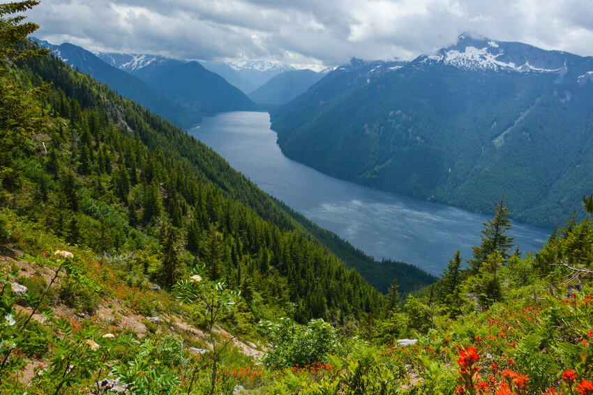 Hike to Flora Pass, B.C. June 23, 2019. Stephen Hui.
Flora Pass
Round trip: 6.8 miles
Elevation gain: 3,640 feet
Access: On Trans-Canada Highway 1 in Chilliwack, take Exit 119. Head south on Vedder Road. At the roundabout before the Vedder Bridge, take the second exit and go east on Chilliwack Lake Road for 24 miles. Before the pavement ends, turn left into the Post Creek parking lot.
Trail: The rewards of the stiff climb to Flora Pass are grand: Wildflower meadows bursting with color and sweeping views of the Cascade Mountains surrounding Chilliwack Lake Provincial Park.
The Flora Lake Trail shares its trailhead with the popular Greendrop-Lindeman Trail. Quickly, turn right at the signed Flora Lake turnoff. Fork left twice and begin climbing steadily in the open woods. Switchback up to a viewpoint and unsanctioned campsite. Look out over cascading Cupola Creek and Chilliwack Lake, the latter impounded by an end moraine left behind by a valley glacier 11,000 years ago.
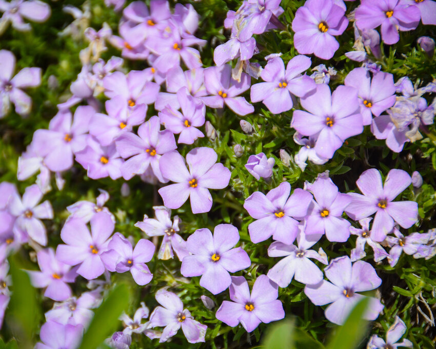
Start a leftward traverse. Hit the third set of switchbacks, as the trees give way to shrubs and more frequent vistas. Another viewpoint and unsanctioned campsite await. Sidehilling across steep, dry, rocky terrain at the headwaters of Cupola Creek, the subalpine scenery is superb. Coast penstemon, globeflower, mountain arnica, Parry’s campion, partridge foot, red paintbrush, spreading phlox, tiger lily, and Western spring beauty star in the flower show.
 Hike to Flora Pass, B.C. June 23, 2019. Stephen Hui.
Duck back into the trees for the final push. Arrive at the summit of Flora Pass. Just over the crest, the Flora Lake Trail forks left en route to eventually reunite with the Greendrop-Lindeman Trail via the Flora Lake Connector. However, wander right along the ridge for a few minutes to score a splendid lunch spot amid white mountain-heather and a glimpse of the gleaming Flora Lake far below. Retrace your steps to the trailhead.
Zoa Peak
Round trip: 5 miles
Elevation gain: 2,030 feet
Access: From Crowsnest Highway 3 near Hope, head north on Yellowhead Highway 5 (Coquihalla Highway) for 27 miles. After cresting Coquihalla Pass, take Exit 221. Turn left to go under the highway via a tunnel. Go left on the other side. Immediately turn right onto the park access road, and drive to the Falls Lake and Zoa Peak parking lot.
Trail: The friendly ridge of Zoa Peak grants hikers easy views of its dramatic neighbors in the Cascade Mountains. In summertime, many hued wildflowers light up the path from almost start to finish. Found on the edge of the Coquihalla Summit Recreation Area, Zoa Peak is a popular destination in all seasons.
Set off north on a gravel road. Keep right at the turnoff for Falls Lake. Heeding signage, turn left on the eroded remains of an old road. After a half-hour, look for a sign and cairn on the left. This is the start of the Zoa Peak Trail proper. Clamber up the steep cut slope, and take the rocky single track into the trees. Encounter small clearings populated with green false hellebore, leafy aster, and mountain arnica, and follow cairns across rocky, open meadows. The grade eases as the pleasant trail swings west to ascend the gentle ridge, amid a bounty of blueberries. Continue through marvelous heather meadows with stunted conifers.
With Zoa’s subpeak in sight, reach an unsigned junction. Detour left on an intermittent path over rock and heather that veers right to visit the east peak and a precipitous south-facing viewpoint just beyond. Falls Lake, a gleaming blue jewel in the glacier-carved valley between Zoa Peak and Thar Peak, reflects the sky.
Back on the main trail, traverse a steep slope below the east peak. Descend to the lush col between the east and main peaks. Before continuing right, go left on a brief path through Sitka columbine and Western pasqueflower to the boulder field on the south side of the col. With pikas calling, stare at the terrifying north face of Yak Peak.
Continue up the main trail, passing by Zoa Peak’s tried and true summit. A sign indicates the end of the marked trail. The final viewpoint, facing northwest, is steps away. A glorious montane landscape spreads out before you. Head back the way you came.
Punch Bowl Pass
Round trip: 10.6 miles
Elevation gain: 3,350 feet
Access: From Trans-Canada Highway 1 in Hope, head east on Crowsnest Highway 3. Keep right and take Exit 177 to stay on Highway 3. Turn left into the Cascade Recreation Area parking lot, 7.8 miles east of E.C. Manning Provincial Park’s west gate.
Trail: Tracing ancient Indigenous pathways, the Whatcom Trail and Dewdney Trail materialized in the mid-1800s as a result of the Fraser Canyon and Rock Creek gold rushes. Today, the pleasant hike to Punch Bowl Pass traverses sections of both historical trails in E.C. Manning Provincial Park. The often steep route heads up the valleys of Snass Creek and its east fork, visiting old-growth trees and subalpine meadows, on the way to the high pass overlooking Punch Bowl, the pretty lake at the headwaters of the Tulameen River.
 Hike to Punch Bowl Pass, B.C. September 14, 2019. Stephen Hui
From the historical marker at the trailhead, embark on the easygoing Dewdney Trail in mature forest. In 30 minutes, reach a signed junction at Snass Forks. Leaving the Dewdney Trail, turn right and drop down the Whatcom Trail to carefully recross Snass Creek on an old slippery bridge. Although markers are few and far behind, the path is well defined, staying on river right of East Snass Creek. Hit the first steep switchbacks and start breathing hard. After an hour on the Whatcom Trail, the path becomes overgrown and, in some parts, badly eroded. Your first partial views are gained – down-valley and across East Snass Creek, now far below. Cross a few streams en route to a good vantage of Snass Mountain at the head of the valley, as the terrain opens up.
Two hours from the junction, the path slices across a dry, rocky slope bearing spreading stonecrop, a succulent plant. Then it’s up a meadow and over a couple of creeks. Punch Bowl Pass is now visible ahead – up and to the left. Higher, in an open meadow beneath Snass Mountain’s west ridge, the wildflowers bloom in technicolor: Edible thistle, green false hellebore, heart-leaved arnica, leafy aster, red paintbrush, tiger lily and Western pasqueflower.
The best southwest-facing viewpoint comes 20 minutes before the destination. Duck back into the trees momentarily. Run along a mossy brook and into a heather meadow with bog blueberries and mountain chickadees. Tread the gentle path to a fork at the summit of Punch Bowl Pass. Take several steps farther to the right to peer down at gleaming Punch Bowl, encircled by lush meadows and verdant conifers, and beyond to distinctive Warburton Peak. Head down the way you came.
Stephen is the author of Destination Hikes In and Around Southwestern British Columbia, a new guide to 55 hiking trips. His first book, 105 Hikes In and Around Southwestern British Columbia, was a #1 B.C. bestseller. Visit 105hikes.com. x


