If you can see Mt. Baker, you are part of The Experience
Urban hikes are having a moment. It seems everywhere you turn, there’s a book, magazine article (ahem) or website touting the benefits of urban hiking. And for good reason: these backyard trails are accessible for nearly all ages and abilities. You don’t need a bombproof, pothole-gobbling vehicle to reach them. Whether you have one hour or four, a quick urban escape is just what the doctor ordered – especially when high-country hikes are covered in snow.
Anacortes hosts some of northwest Washington’s best urban hikes. Located on Fidalgo Island, Anacortes’ extensive trail network offers excellent sea and island views in exchange for relatively little effort. Hit these three trails during winter (or any time of year) for a quick, rewarding dose of the outdoors – the ultimate antidote to cabin fever.
Distance: 2.8 miles round trip
Elevation Gain: Minimal
Getting There: From downtown Anacortes, head west on 12th Street (WA-20). Drive 1.1 miles and continue straight onto Oakes Avenue. After 1.6 miles, turn right onto Ship Harbor Boulevard. Drive 300 feet, then turn left onto Edwards Way. Park in the cul-de-sac at the end of the road. No pass needed.
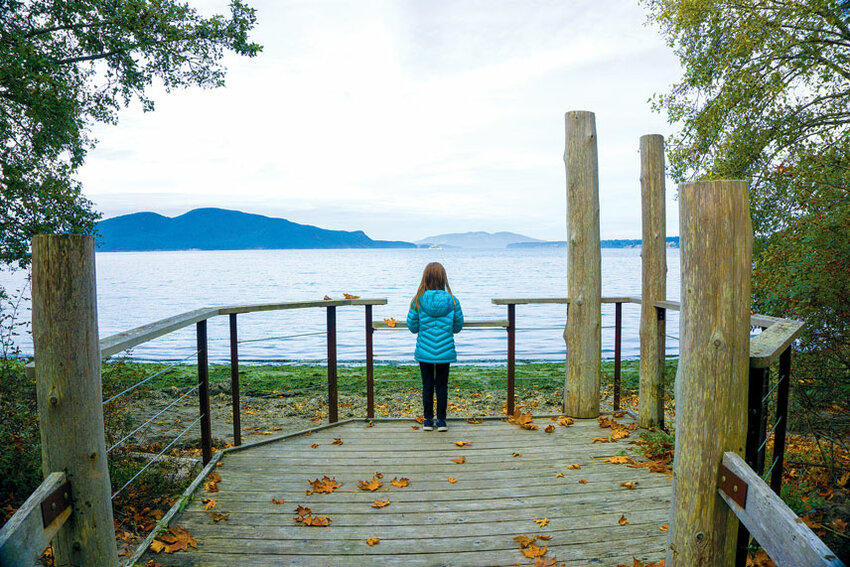
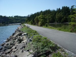
The Trail: A pair of saltwater shoreline walkways connected by cul-de-sac, Guemes Channel and Ship Harbor trails provide a scenic urban outing for all ages. Begin by walking west on the gravel Ship Harbor Trail. The trail runs parallel to a sandy beach with views of the San Juan Islands across Ship Harbor. At 0.3 miles reach a wetland boardwalk, following the short loop to return to the parking area.
Back at the cul-de-sac, head east on the Guemes Channel Trail. This paved path may one day run the length of Anacortes’ waterfront, connecting the San Juan Ferry to the Tommy Thompson Trail. For now, you can stroll 1.1 miles to the trail’s temporary end at Lovric’s Marina. The raised Guemes Channel Trail lacks beach access, but makes up for it with expansive, unobstructed views of Cypress and Guemes islands across Guemes Channel. On clear days, you can even see Mt. Baker to the east.
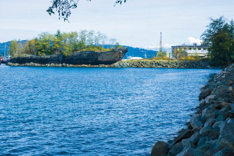
Once you spot La Merced – a schooner-turned-breakwater at Lovric’s Marina – it’s almost time to turn around. Trail-end fence signs explain the ship’s storied history, busting any myths about a shipwreck on Fidalgo Island’s shores. For more information and to support the expansion of Guemes Channel Trail, visit Anacortes Parks Foundation at guemeschanneltrail.com.
Trail Tip: The Ship Harbor boardwalk continues west to the San Juan Island ferry terminal, making this trail a great leg-stretch option for those waiting in the ferry line.
Distance: 2.6 miles round trip
Elevation Gain: 400 feet
Getting There: From Exit 230 on Interstate 5, take WA-20 West for 11.3 miles. At the traffic circle, take the 2nd exit and stay on WA-20 West. Continue 0.7 miles. At another traffic circle, take the second exit to stay on WA-20 West. Continue 4.4 miles, then turn right onto Rosario Road. Drive 200 feet, then turn left onto Bowman Bay Road. Continue 0.3 miles, then turn left for the Bowman Bay parking area. Discover Pass required.
 The Trail: To get a little farther from the Anacortes, head for the south end of Fidalgo Island. Here you’ll discover Deception Pass – Washington’s most-visited state park. Just 20 minutes from town, the park showcases the best of coastal Washington, from pebble-strewn beaches and headland heights to evergreen forest trails.
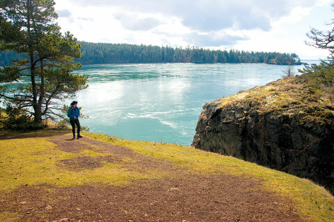
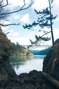
From Bowman Bay, walk south along the beach to check out two forested loops: Lottie Point and Lighthouse Point. These two trails offer excellent views over the churning waters of Deception Pass. Check out the historic Deception Pass Bridge (built in 1935) from afar, then return to Bowman Bay and consider a hike to Rosario Head.
Trail Tip: Hike north from Bowman Bay to extend your hike to Rosario Head for sweeping San Juan Island views from 60-foot sea cliffs. You can also drive across Deception Pass Bridge and explore the south (Whidbey Island) side of the park.
Distance: Up to 6.6 miles round trip
Elevation Gain: Minimal
Getting There: For the south trailhead, take Fidalgo Bay Road (parallel to WA-20 south of town) to Weaverling Road, about 2.5 miles south of downtown. Turn northeast onto Weaverling and continue 0.1 mile to a small pullout parking area on the right. For the north trailhead, park in the large paved lot at Cap Sante Marina (east end of 11th Street). No pass needed.
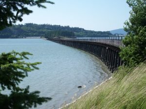
The Trail: Stretching from the edge of downtown Anacortes to a trestle over Fidalgo Bay, Tommy Thompson Trail is a longtime local favorite. You can walk up to 6.6 miles round-trip on this paved trail or skip the less scenic northern section with a shorter walk along the south end.
For the very best of the trail, begin at Fidalgo Bay Resort and head east from the trail junction with Weaverling Road. Walkers, joggers, families with strollers and just about everyone else can cruise along the causeway with ease. But don’t rush – take your time and you’ll be more likely to spot wildlife in the surrounding waters. Loons, herons and more feathery friends hang out here on the regular. Once you reach the trestle, peer down into Fidalgo Bay for a chance to see otters frolicking below. The trail ends at March’s Point Road, one mile from Fidalgo Bay Resort, for an easy two-mile round-trip trek.
From the north trailhead at Cap Sante Marina, users have easy access to the Tommy Thompson Trail right outside downtown Anacortes. This urban access point is convenient, but not nearly as serene as the south end. Take advantage of your proximity to downtown by exploring local restaurants and businesses. Then drive (or walk) up to Cap Sante Park for sweeping saltwater, island and Cascade Mountain vistas.
Trail Tip: If visiting on a Saturday, check out the Anacortes Farmers Market for a pre- or post-hike snack. The market is located at the intersection of 7th Street and R Avenue, within walking distance of Cap Sante Marina. See anacortesfarmersmarket.org for details. x


